
Stratigraphy: Recovering Data in the Low Desert

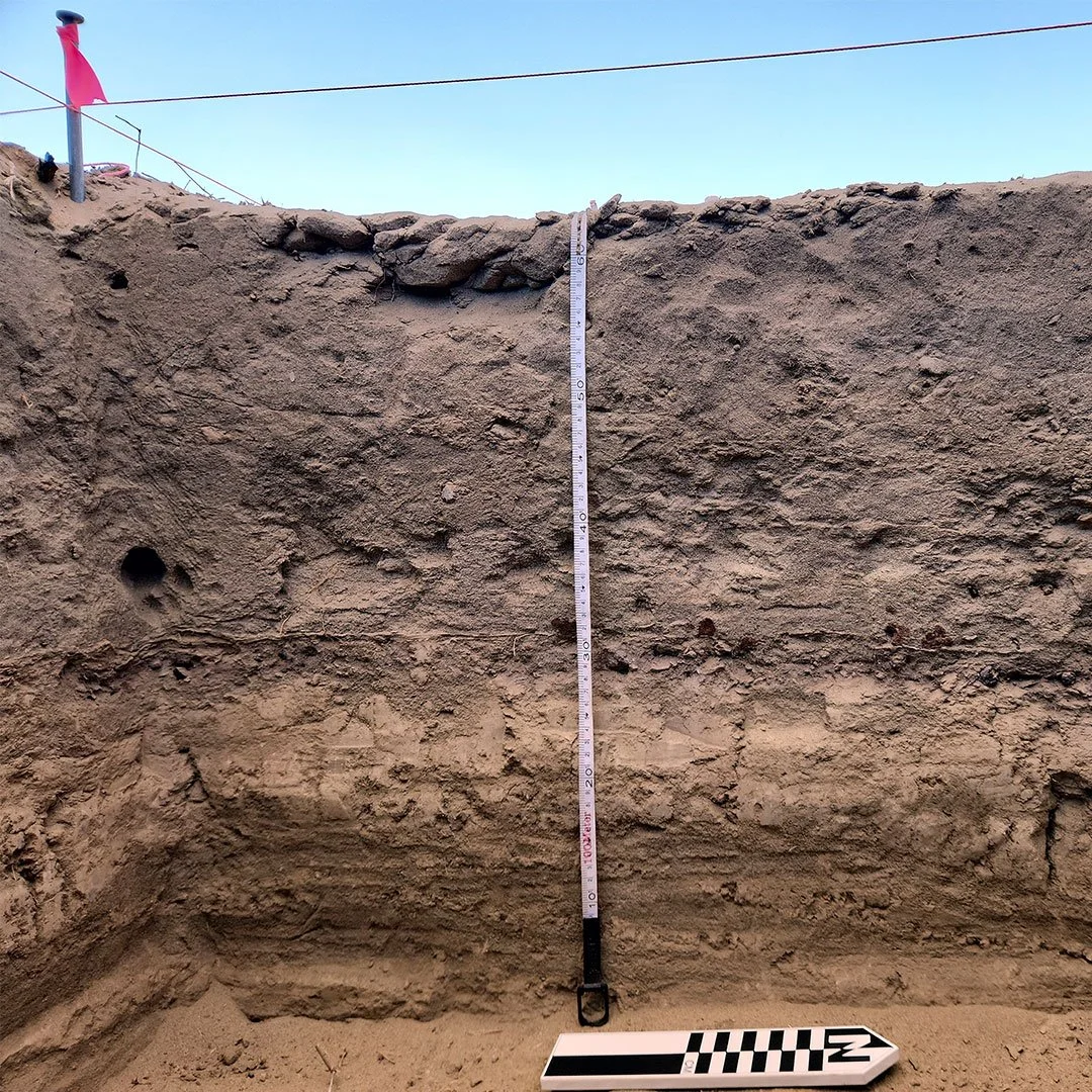
The stratigraphy is clear in this photograph of a sidewall of an excavation unit.
One of the most fundamental concepts in archaeology is that of stratigraphy.
It refers to the layers of dirt that accumulate through deposition over time. Archaeologists read stratigraphy in order to understand what happened in the past. These layers are the key to understanding how old archaeological material is (i.e., artifacts, buildings, etc.), how it came to be buried, and how material within a given site is interrelated.
In the Coachella Valley, a recent development project took place at which BCR Consulting archaeologists were employed to excavate a Native American archaeological site. The site was identified during the initial cultural resources assessment stage (Phase 1) and was found to be significant and therefore protected under CEQA. By fully excavating the site, BCR Consulting mitigated potential impacts to it and made it possible for the project to continue as planned – on schedule.

This diagram is a detailed sketch of the same sidewall pictured above to better convey the layers that were present and represent what each layer consisted of.
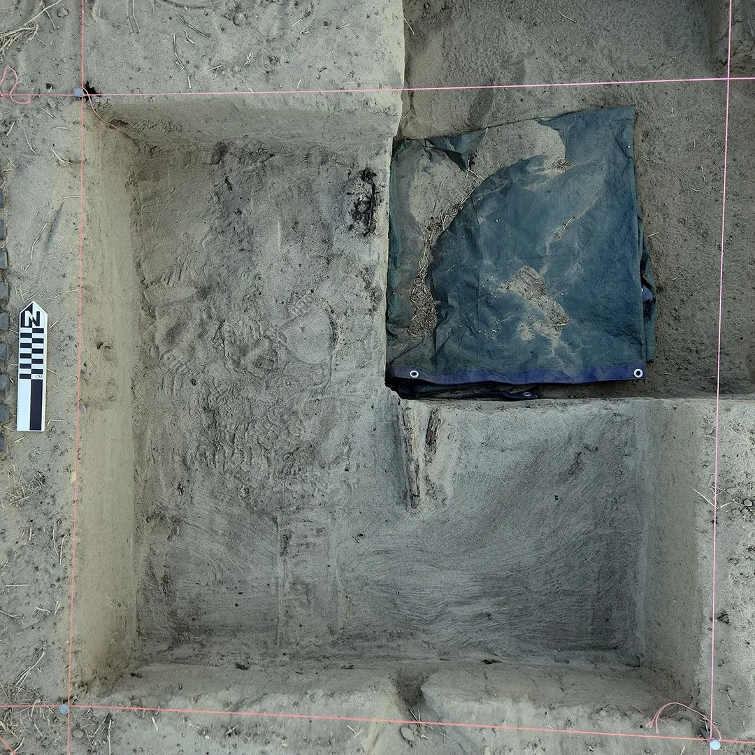
The site consisted of an extensive surface scatter of ceramic and other material, as well as a buried campfire which also contained some artifacts. During this excavation, it was important for our archaeologists to record and understand the stratigraphy. Based on prior research and concurrent geological investigations taking place on site (discussed further below), we confirmed that just underneath the campfire was a thin layer of hardened clay. The fact that this layer was comprised of clay indicated that it was deposited during the last period that Ancient Lake Cahuilla was present there. The artificial (and accidentally-created) Salton Sea now occupies the natural sink of the former (and much larger) Lake Cahuilla. Presently, this site is more than 20 miles away from the Salton Sea shoreline.
As we dug deeper, more and more layers were revealed.
Geoarchaeologist Gary Huckleberry, Ph.D., conducted underground testing within the site to further study its stratigraphy. BCR Consulting directed the backhoe excavation of three large trenches (three meters deep) so that he could observe a much deeper cross section of the stratigraphy than would be possible in the shallower archaeological excavation units. In these trenches, Dr. Huckleberry observed that, below that uppermost thin clay layer (corresponding to the clay layer observed below the campfire), alternating layers of sand, clay, and silt were present. Considering multiple lines of evidence, including the local topography and the site’s position within the shoreline of Ancient Lake Cahuilla, Dr. Huckleberry determined that the sediment within the trench was consistent with fluctuating lake shore environment.

BCR Consulting directed the backhoe excavation of three large trenches (three meters deep).
The sidewall of one of the trenches that were excavated to observe stratigraphy, thus gathering data used to determine that all of this sediment was likely deposited by Ancient Lake Cahuilla
The knowledge gained from this observation of the stratigraphy, combined with radiocarbon dates that we obtained from the charcoal in the campfire, provided us with a date range for the buried archaeological material. Radiocarbon dates suggest an occupation between 1727 to 1787 cal AD. A recent study (Rockwell et al. 2022) suggested that Ancient Lake Cahuilla’s most recent high stand (a time when it was full) occurred between 1731 and 1733 AD. Such a high stand would have taken decades to drain to a level near the Salton Sea’s current shoreline. Therefore, it is likely that it would have taken at least several years for the lake to drain enough to expose the area on which this archaeological site was formed. It follows that the site’s date range can be narrowed to sometime around 1740 to 1787 AD.
This time frame fits well with what we know about the artifacts recovered from within the campfire. Among these artifacts were two glass flakes. This type of artifact is produced as a byproduct when glass (which was not manufactured by pre-contact Native Americans) is worked to make tools like arrowheads. The fact that a European material was worked in a traditional manner like this suggests that it was produced by Native Americans after Europeans had some presence in Southern California, but before European settlements had proliferated extensively.
Based on this information, BCR Consulting archaeologists were able to rule out the likelihood of additional archaeological deposits being present below the campfire. The dirt below that feature was deposited by multiple cycles of Lake Cahuilla filling and emptying. This type of process is disruptive and would have removed any material that could have been left behind by people in the past (the campfire was only present because it was on top of the final cycle). Therefore, we did not have to continue excavating by hand (a much slower process than digging the large trenches) far below the campfire in search of additional archaeological deposits.
Stratigraphy was of vital importance to all of these interpretations. Without it, we would not have been able to learn nearly as much about what happened at this site in the past. And, importantly, we would have had to spend more time digging. Thankfully, stratigraphy aided BCR Consulting archaeologists to be as efficient as possible. This resulted in a project that was completed on schedule, and under budget.
References
Rockwell, Thomas K., Aron J. Meltzner, Erik C. Haaker, and Danielle Madugo. 2022. The late Holocene history of Lake Cahuilla: Two thousand years of repeated fillings within the Salton Trough, Imperial Valley, California. In Quaternary Science Reviews, 282.